What Was Hurricane Huron?
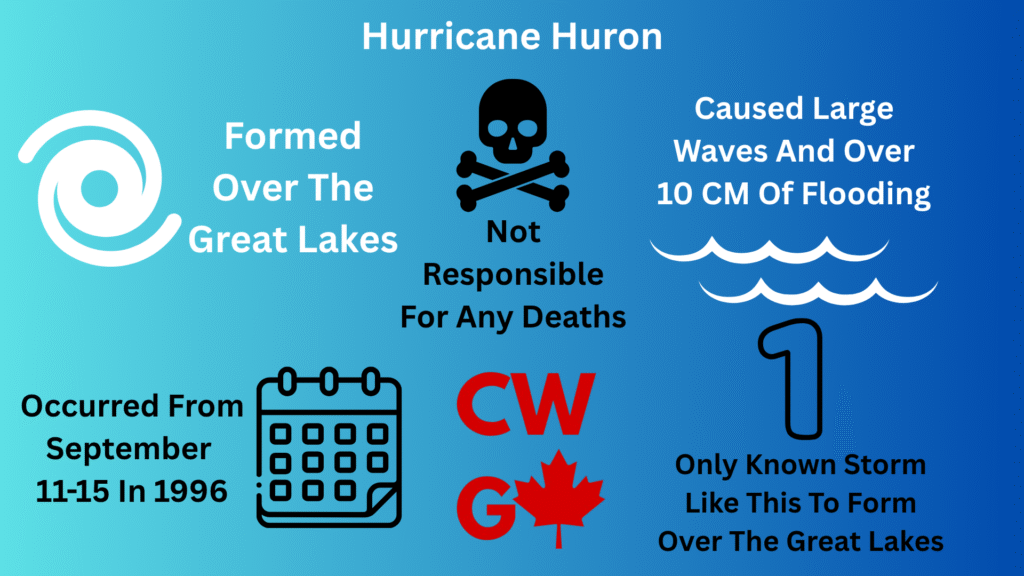
Hurricane Huron, also known as the 1996 Lake Huron Cyclone, the 1996 Great Lakes Cyclone, or “The Hurroncane” was a storm that occurred over the Great Lakes in September of 1996. The storm had the sustained strength as a tropical storm, with some brief gusts reaching hurricane strength. It should be noted that this storm was never officially named “Hurricane Huron” due to not being part of the ‘official’ 1996 hurricane season, but was given that nickname due to the fact that it was at its most powerful while it was over Lake Huron.
When Was Hurricane Huron?
The storm that became Hurricane Huron started off as a low-pressure area near Lake Superior on September 11, 1996, and headed East. By the 13th, the storm had stopped over Lake Huron and was at its peak.
How Long Did Hurricane Huron Last?
Hurricane Huron lasted until September 15.
Why Was Hurricane Huron So Unusual?
Most hurricanes start out in the middle of the ocean, although based on where it started, it might be referred to as a Typhoon, Cyclone, or some other name. They also form near the equator. This is the most common place for hurricanes to form, due to the large amount of warm water that is usually needed to form such a storm. Due to how cold the Great Lakes usually are, and the fact that they are not nearly the size of an ocean, it is very unusual for storms of this magnitude to start there. Even though a storm like Hurricane Hazel that starts off in the tropics can reach the area, it is rare for a storm to travel both far inland and far north enough for it to remain at hurricane strength long enough to reach the Great Lakes.
Due to its unusual location, it was not officially part of the 1996 Atlantic Hurricane season and was not named according to that system’s naming pattern.
How Did Hurricane Huron Form?
An area of low pressure was close to Lake Superior on September 11, 1996, and it slowly moved over to Lake Michigan. It kept its momentum going, and by the 12th, had reached Lake Huron, where it stopped. Over the next few days, it floated over the lake, picking up some strength. When looked at by satellite during this time, it resembled a tropical storm or hurricane, having a large white area filled with rain clouds, and even had a small, calm eye in the middle. By the 15th, the storm weakened and moved westward before dissipating over Lake Erie and Lake Ontario.
It should be noted that fall is usually when the water in the Great Lakes is at its warmest, making this the most likely time for such a storm to form. However, the Great Lakes are usually too cold and too small to form such a storm. Hurricane Huron was a very unusual exception.
How Powerful Was Hurricane Huron?
Hurricane Huron was much stronger than most storms that form around that area, with estimated wind speeds from 115 km/h (71 mph) to 120 km/h (75 mph). It should be noted that this puts it well above the level needed for a tropical storm of 63 km/h (39 mph), and borders the amount needed to reach the level of a category 1 hurricane according to the Saffir-Simpson Scale, which requires winds of 119 km/h (74 mph). This has caused meteorologists to not have a clear idea of exactly what to call this, or even categorize it. 10 cm (4 inches) of rain fell during the storm.
How Much Damage Did Hurricane Huron Do?
Luckily, damage caused by Hurricane Huron was relatively minimal. Unusually large waves formed around Lake Huron and Lake Erie, with flooding of over 100 mm forming in many places, in both Canada and America. Luckily, very little damage to personal and public property was noted.
How Many People Died In Hurricane Huron?
Luckily, nobody was killed by Hurricane Huron, and there were also no significant injuries.
Can Something Like Hurricane Huron Happen Again?
Theoretically, although unlikely to happen in any one year, it is very much possible for such a storm to happen again, especially with global warming happening. If the waters in the Great Lakes warm up, the region could become more prone to powerful storms such as Hurricane Huron. With global warming and climate change getting more and more powerful, albeit very slowly, it is indeed possible for such a storm to become somewhat frequent, although there is no way to give a precise timeline or odds of such a thing happening.